10

I hope you excuse the sloppiness of the following description, but I'd like you to realize that only a qualitative approach –instead of a desired quantitative one– is possible. (Otherwise, if you provide the data, I'd be happy).

The question in a pair of words is explain this division line (see bellow the actual question).
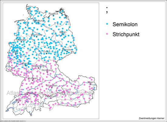
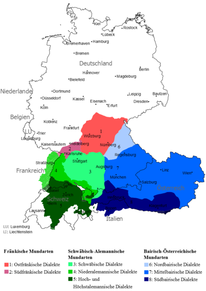
enter image description here

Want to see it again? (not so clearly, though)
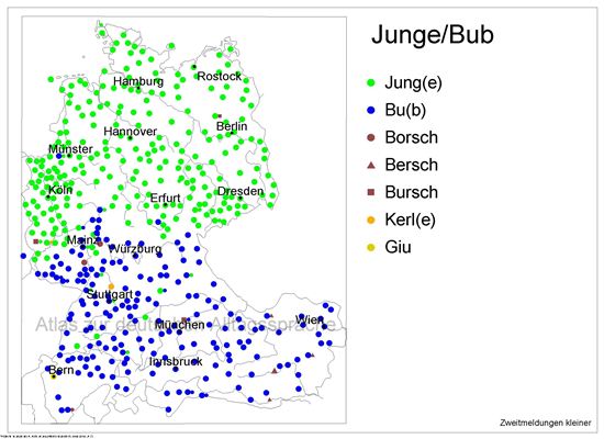
enter image description here

Or, like here, that line is lower, but still inside Germany and encompassing most Bayern and Baden-Württemberg:
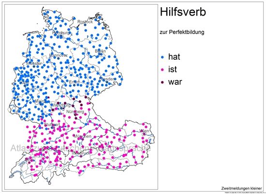
enter image description here

No, seriously, that line doesn't appear only once. I've been browsing some minutes on the AdA, and I find that pattern quite often.

I think it's interesting because one could expect that abrupt division on the boarder of a country, but inside a country is somehow counterintuitive.

  • Is there an objective argument explaining this rather unexpected behaviour?
3
  • 4
    I would never call this an unexpected behaviour. The division between High and Low German has been there for centuries, before the current borders existed. I would assume that's the cause of these phenomena. Luther was very important when it comes to the German language, but the German he used was High German, which the people from the north had to learn in order to understand the Bible while the dialects in the south kept evolving on their own. Since I don't have any specific sources (except for Wikipedia) I'll just leave this as a comment.
    – clinch
    Commented Mar 5, 2014 at 18:25
  • 1
    Viele Sprachen folgen keinen politischen Grenzen. Wieviele Nationen sprechen Englisch, Französich? Was sprechen Kurden? Die Niederlande sind sprachlich gespalten, die Schweiz. Es scheint doch eher die Regel als die Ausnahme. Commented Mar 6, 2014 at 5:57
  • @c.p. In Norddeutschland gibt es eine Dänischsprachige Minderheit mit Sonderrechten. In Ungarn und Rumäninen gibt es deutschsprachige Minderheiten. Commented Mar 7, 2014 at 4:22

4 Answers 4

10

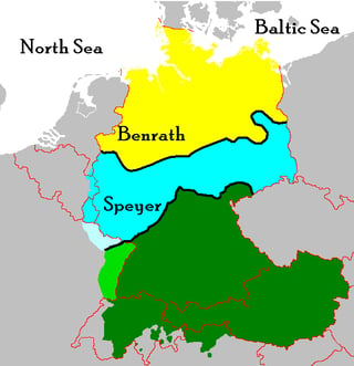
The maps shown by the Atlas der deutschen Sprache follow closely the Speyer Line, a line separating german dialects from middle Germany and southern Germany (Upper German / Oberdeutsche Dialekte):

enter image description here

Image source: Wikimedia

This line is related to the Benrath Line further north where the linguistic separation of High German (south) and Low German (north) took place.

In the map above it can be seen that the dialects in Alsace (France), Switzerland, South Tyrol (Italy) and Austria are Upper German as well.


enter image description here

High German subdivides into Upper German (green) and Central German (blue), and is distinguished from Low German (yellow) and Dutch. The main isoglosses, the Benrath and Speyer lines, are marked in black.

Source: Wikipedia

2
  • Ich war so frei und hab ein 2. Bild, welches die Spreyer Linie deutlicher darstellt, eingefügt. Deine Antwort ist wesentlich besser als meine, da sie das Ganze auf Sprachebene erklärt und nicht auf Basis territorialer Regentschaften. +1
    – nixda
    Commented Mar 6, 2014 at 9:30
  • @nixda: danke schön, ich hatte ursprünglich auch ein Bild mit den Benraht/Speyer-Linien und habe es aber durch obiges ersetzt, weil da auch Fr und It vorkommt... Beide Bilder ist auch gut :)
    – Takkat
    Commented Mar 6, 2014 at 9:50
7

Germany united very late in history. There are volumes of books about what happened between ~1800 (when Germany consisted of a plethora of small kingdoms, duchies, free citys, and other entities) and 1918, when there was, for the first time, a united german nation. (And it wasn't even clear until after WW1 if Austria should be a state of its own or a part of germany; the winners of the war decided 2 states would be less dangerous that one). This shows a few maps what happened in that time.

But Germany didn't, unlike many other nations, have a central power that defined what "correct" german was. Other nations, like France were much more centralized, trade and cultural exchange happened mostly within the state borders. But for a merchant, in what is now southwest germany, it was much more likely to visit Vienna (along the river Danube) than to visit, for example, Berlin. So, unification of dialects, especially along borders of current nations, just didn't start until about 100 years ago.

6

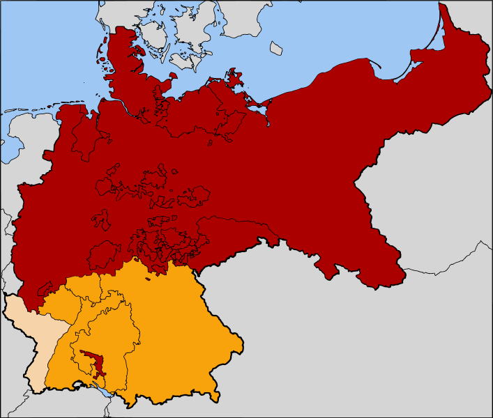
In addition to Guntram's answer I'd like to point you to the years 1867–1871, the North German Confederation and the Austro-Prussian war. A moment in history where you can see the line and a possible answer to your question.

The Austro-Prussian War or Seven Weeks' War was a war fought in 1866 between the German Confederation under the leadership of the Austrian Empire and its German allies on one side and the Kingdom of Prussia with its German allies and Italy on the other, that resulted in Prussian dominance over the German states.

The Kingdom of Bavaria and the Kingdom of Württemberg were on the side of Austria while most of the other German Kingsdoms where allies of Prussia.

enter image description here


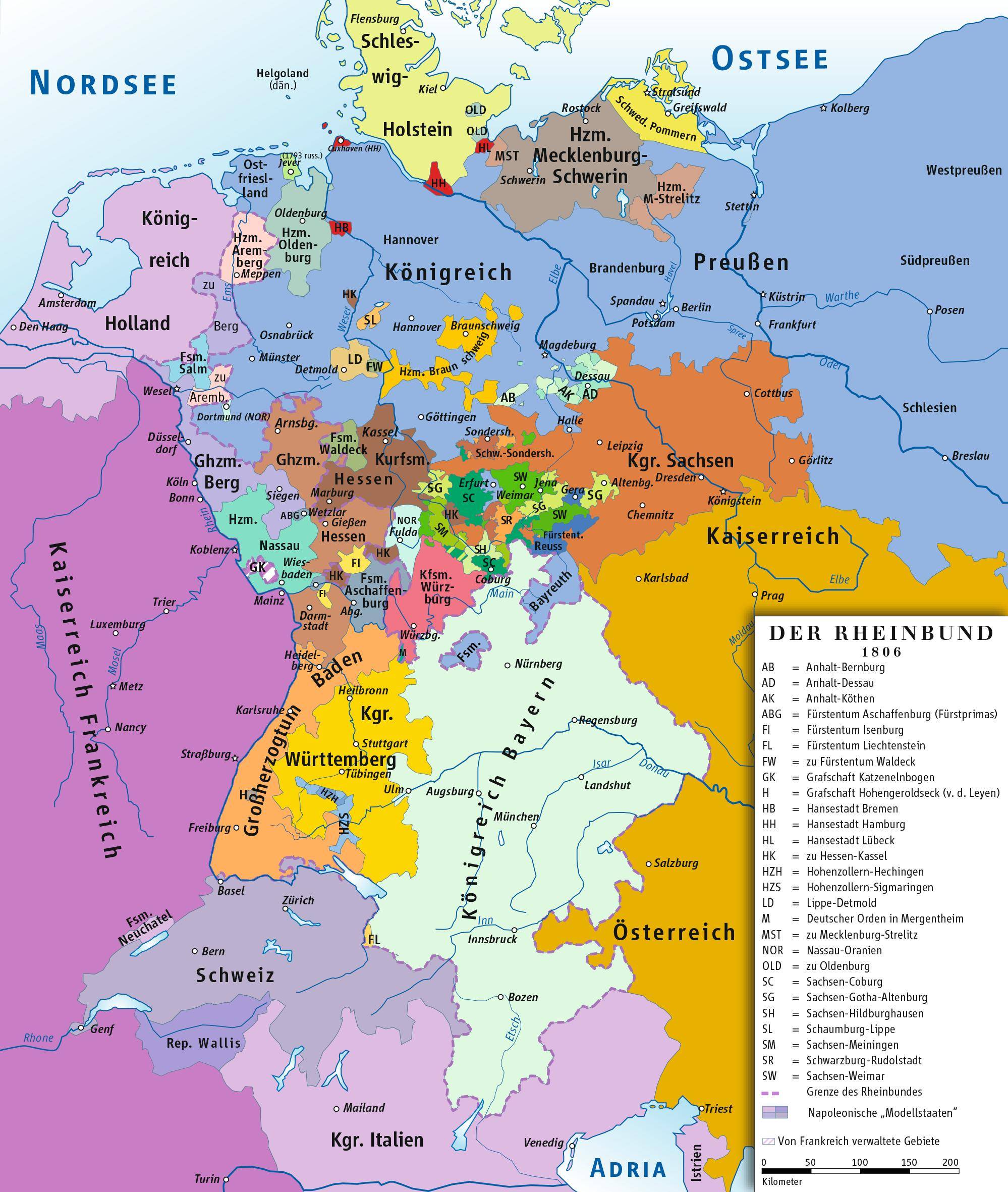
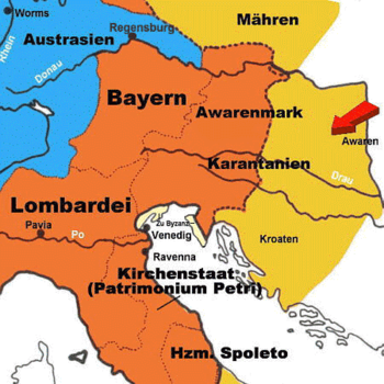
The close connection between Bavaria and Austria existed for centuries, only the boundaries have shifted over time. The following two maps show that major areas of todays Austria and Bavaria once shared the same government.

1806 - 1813 - Confederation of the Rhine

enter image description here

996 - Bavaria as part of the Frankish Kingdom

enter image description here

3
  • 1
    4 Jahre scheinen ziemlich dünn, um darauf einen Sprachgebrauch zu gründen, der bis heute fortwirkt. Commented Mar 6, 2014 at 5:54
  • @userunknown Das stimmt. Ich hatte diesen Zeitpunkt gewählt, da er am extremsten die Rivalität zwischen Nord und Süd darstellte. Ich habe die Antwort erweitert um 2 Karten, die die Verschiebung des bayrischen Kernlandes über die Jahrhunderte darstellt.
    – nixda
    Commented Mar 6, 2014 at 9:16
  • Damit ist der Krieg (immerhin ein Einzelereignis in Jahrhunderten) eher eine Folge (oder ein Ausdruck) der Sprache (und einem riesigen Konglomerat anderer regionaler Unterschiede, Allianzen und Interessen unterschiedlich ist) als andersrum, wie deine Antwort anscheinend implizieren will.
    – tofro
    Commented Nov 4, 2021 at 7:07
0

Ich denke es ist hier gar nicht zwingend notwendig mit Karten um sich zu schmeißen. Ländergrenzen bedeuten nicht Sprachgrenzen. Was sich irgendwo entwickelt hat, wird sich vermutlich entweder ausweiten oder zurückentwickeln. Nahe der niederländischen Grenze z.B. sprechen und verstehen ansässige oft sowohl Niederländisch als auch Deutsch (in beiden Ländern) - bei gleicher Sprache mit unterschiedlichem Dialekt wird dies natürlich noch vereinfacht. Durch Pendler, Umzüge etc. wurde und wird "neues" wohl immer weiter getragen, egal ob es sich um Sprache, Formulierungen, Sprichwörter, Bräuche etc. handelt.

2
  • Natürlich wird in Grenzgebieten häufig zweisprachig gelebt. Das ist auf der ganze Welt so und keine süddeutsche Besonderheit. Insofern hast du recht. Aber wir reden hier nicht von einem schmalen Grenzstreifen, sondern von 30% der deutschen Landmasse, einer Sprachgrenze, die 480 km entfernt liegt von der deutschen Grenze zu Schweiz/Österreich. Das ist schon etwas Besonderes und lässt sich nicht durch normale "Diffusion" erklären :D
    – nixda
    Commented Mar 6, 2014 at 11:54
  • @nixda: doch, natürlich, wenn es schon sehr lange so ist, bzw. vor langer zeit begann, dann zieht es entsprechend große kreise.. was anderes wäre es, wenn es dazwischen eine Zone geben würde, in der es anders ist.. Commented Mar 6, 2014 at 12:22

Your Answer

By clicking “Post Your Answer”, you agree to our terms of service and acknowledge you have read our privacy policy.

Not the answer you're looking for? Browse other questions tagged or ask your own question.